
Alliance Simulation
Backstory
Original Map Version
During the 1982-83 school year as a sophomore, I was introduced to an Alliance Game
.
It lodged itself in my subconscious for the next seventeen years. As I took on my first teaching assignment in 2000,
I remembered this game
and how it reinforced the concept of alliances during World War One.
The revolution in informational technology, namely the internet, allowed me to locate the
Alliance Game
.
The information was as I had remembered, yet there was no map! This is the most essential element of the entire simulation.
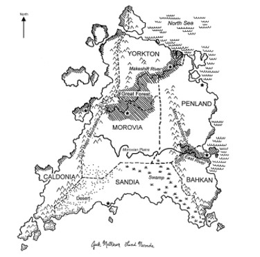
Then I remembered how the teacher had simply given us a handrawn map, which at the time was quite effective.
In 2001, I had a student who wanted to be an architect.
As an assignment, I gave him the geographic parameters from the game
as well as a set of rapidograph drafting pens.
He drew a beautiful black and white map by hand. No computer was involved. The text were dry-transfers.
In other words, he created a map the old-fashioned cartographic way.
The original map was used until 2006, when color was introduced. Previously, the country information was simply photocopied on the six colored paper choices available. The current country colors are a direct descendant of these choices. The eight nation map is the fourth version and is entirely digitized. It includes the largest change yet to the original map.
The factual information has transformed considerably from the original version. Much has been added and/or simplified. The names of the countries have been retained to pay homage to whoever first came up with such a wonderful teaching concept.
The primary catalyst for change is experience with students playing the game.
Young humans are amazing creatures and given a chance will work out incredible solutions.
The improvements are in response to the best editors a teacher could ever have.
For example, the Country Confidential Information was put in a booklet with a transparent cover.
This was simply so the booklets could be reused and the map could be seen.
A student requested washable overhead markers to draw out his plans
.
Ever since, these markers have become part of the simulation.
Explore the information. Read the lesson plans, paying close attention to the caveats. If you want a wonderful experience with your students, please give this a try.